Property Record
3411 Highway 53 E, Jasper, GA 30143
NEARBY LISTINGS FOR SALE OR LEASE
-
-
No Photo
-
View all Jasper listings for sale on LoopNet.com
Property Detail
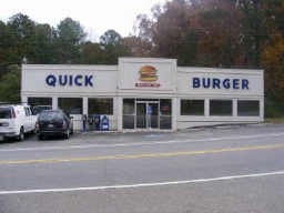
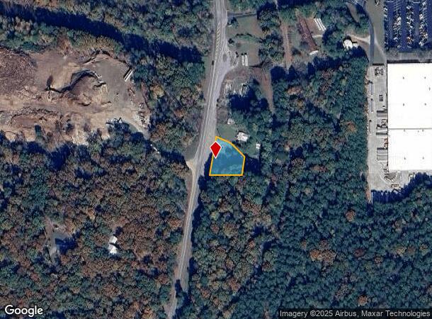
3411 Highway 53 E
052A-000-006-000
County Commercial
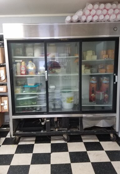
Restaurantbuilding
DIST4 LL79 .48AC QUICK BURGER
X
Pickens
13057C0070E
Georgia
2024
0.48 AC
2024
Pickens County
050601
Atlanta
1,708 SF
Atlanta-Sandy Springs-Roswell, GA
DEMOGRAPHICS near 3411 Highway 53 E
1 Mile
3 Mile
5 Mile
2024 Total Population
559
8,208
18,952
2029 Population
621
9,241
21,309
Pop Growth 2024-2029
+ 11.09%
+ 12.59%
+ 12.44%
Average Age
43
44
44
2024 Total Households
216
3,269
7,475
HH Growth 2024-2029
+ 11.11%
+ 12.73%
+ 12.33%
Median Household Inc
$68,684
$75,478
$73,998
Avg Household Size
2.50
2.40
2.50
2024 Avg HH Vehicles
3.00
2.00
2.00
Median Home Value
$234,146
$275,856
$274,328
Median Year Built
1985
1990
1992
Nearby Places
Map Layers
Map Styles
 Street
 Aerial
- Restaurants
- Banks
- Shops
- Fitness
- Groceries
SALE & LEASE HISTORY
LISTING DATE
SALE/LEASE

Sep 27, 2017
For Sale
Oct 14, 2019
For Sale
Nearby Properties
Address
Land Use
TOTAL SIZE
Lot Size
Zoning
Address
Land Use
TOTAL SIZE
Lot Size
Zoning
1,120 SF
136.24 AC
HB
Address
Land Use
TOTAL SIZE
Lot Size
Zoning
4,800 SF
31.59 AC
HB
Address
Land Use
TOTAL SIZE
Lot Size
Zoning
4,512 SF
22 AC
R-3
Address
Land Use
TOTAL SIZE
Lot Size
Zoning
10,000 SF
38.60 AC
HB
Address
Land Use
TOTAL SIZE
Lot Size
Zoning
60,684 SF
5.42 AC
C-2
Address
Land Use
TOTAL SIZE
Lot Size
Zoning
14.75 AC
C-2
Address
Land Use
TOTAL SIZE
Lot Size
Zoning
29,236 SF
3.44 AC
HB
Address
Land Use
TOTAL SIZE
Lot Size
Zoning
213,868 SF
170.62 AC
HB
Address
Land Use
TOTAL SIZE
Lot Size
Zoning
13,532 SF
21.37 AC
HB
Address
Land Use
TOTAL SIZE
Lot Size
Zoning
22,360 SF
28.31 AC
M-1
Address
Land Use
TOTAL SIZE
Lot Size
Zoning
719.19 AC
AG
Address
Land Use
TOTAL SIZE
Lot Size
Zoning
1,247 SF
10 AC
R-1
Address
Land Use
TOTAL SIZE
Lot Size
Zoning
743.09 AC
SR
Address
Land Use
TOTAL SIZE
Lot Size
Zoning
22,560 SF
10.29 AC
C-2
Address
Land Use
TOTAL SIZE
Lot Size
Zoning
18,300 SF
4.46 AC
C-2
Address
Land Use
TOTAL SIZE
Lot Size
Zoning
1,456 SF
308.12 AC
AG
Address
Land Use
TOTAL SIZE
Lot Size
Zoning
5,248 SF
9.53 AC
R-1
Address
Land Use
TOTAL SIZE
Lot Size
Zoning
31,925 SF
5.69 AC
C-2
Address
Land Use
TOTAL SIZE
Lot Size
Zoning
1,792 SF
3.28 AC
HB
Address
Land Use
TOTAL SIZE
Lot Size
Zoning
6,000 SF
20.30 AC
C-2
Address
Land Use
TOTAL SIZE
Lot Size
Zoning
14,772 SF
2.08 AC
C-2
Address
Land Use
TOTAL SIZE
Lot Size
Zoning
27,014 SF
5.76 AC
C-2
Address
Land Use
TOTAL SIZE
Lot Size
Zoning
4,000 SF
0.40 AC
I
Address
Land Use
TOTAL SIZE
Lot Size
Zoning
15,142 SF
9.84 AC
HB
Address
Land Use
TOTAL SIZE
Lot Size
Zoning
5,130 SF
3.95 AC
HB
Address
Land Use
TOTAL SIZE
Lot Size
Zoning
9,960 SF
7.25 AC
HB
Address
Land Use
TOTAL SIZE
Lot Size
Zoning
19,808 SF
1.75 AC
HB
Address
Land Use
TOTAL SIZE
Lot Size
Zoning
1,653 SF
45.31 AC
R-A
Address
Land Use
TOTAL SIZE
Lot Size
Zoning
8,510 SF
8.50 AC
PUD
Address
Land Use
TOTAL SIZE
Lot Size
Zoning
5,448 SF
30.17 AC
HB
The World's #1 Commercial Real Estate Marketplace
Connect with us
© 2025 CoStar Group
The information above has been obtained from sources believed reliable. While we do not doubt its accuracy we have not verified it and make no guarantee, warranty or representation about it. It is your responsibility to independently confirm its accuracy and completeness. Any projections, opinions, assumptions, or estimates used are for example only and do not represent the current or future performance of the property. The value of this transaction to you depends on tax and other factors which should be evaluated by your tax, financial, and legal advisors. You and your advisors should conduct a careful, independent investigation of the property to determine to your satisfaction the suitability of the property for your needs.